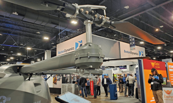
Even on the show floor at Xponential 2022, with innovative ideas on display in nearly every booth, this new platform from Orthodrone in Germany stood out. Looking at is it might have dropped fully formed from the imagination of George Lucas—to hunt down the Rebel Alliance on behalf of the Galactic Empire—the unnamed multirotor features a pair of limbs supporting its eight motors which themselves can pitch and roll.
This is the exact opposite of a conventional drone, where the camera gimbal pitches and rolls to compensate for the movement of the aircraft, to capture steady aerial videos or still photographs. To find out what accounted for this extraordinary—and extraordinarily cool-looking—design, I spoke with the company’s CEO: Juri Klusak.
“When the drone moves, it doesn’t have to move its entire 55-pound mass when it’s hit by a gust of wind, or something. Instead, it’s just moving its arms, its propellers and therefore the vectors of thrust—and that does a good job of stabilizing the payload,” he said.
Of course, that answer prompted an immediate follow-up question: Why not use what is a well-proven approach in the industry at this point and just mount the payload on a gimbal?
“We’re in the mapping sector, and we do a lot of work in really harsh environments—on board icebreakers in the arctic, for example,” Klusak explained. “On top of that, we’re using survey-grade instruments, like multiple, 100-megapixel cameras from Phase One and a Riegl LiDAR system.”
Together, these instruments make up a significant portion of the aircraft’s overall weight, which would require an extremely large gimbal to support. In addition, even with the sensors mounted on a gimbal, the aircraft’s inertial measurement unit (IMU), and GPS receivers would still be on the airframe—and therefore moving relative to the sensors. By making the drone itself the gimbal, all of these systems operate from the same stabilized platform.
If the mapping work you are doing requires a ground sample distance of one pixel per centimeter, which is typical for missions using small commercial UAS, this degree of stability isn’t required. However, as Klusak explained, the work done by his company is required to meet much higher standards.
“For instance, we mapped a dam in the Swiss Alps with a 0.5mm resolution—and for that kind of work, you need the right equipment,” he said. “As a service provider, we realized that from the data we could do a lot more, but we didn’t have the right tools. So, that’s why we ended up building this.”
The aircraft can fly for two hours, powered by a water-cooled Pegasus GE 70 two-stroke engine providing 4,000 watts of power. Then, the aircraft can be quickly refueled and launched again to continue the mission.
“For the environments that we work in, we usually don’t have the option to re-charge batteries,” said Klusak. “With a gas-burning engine, you just bring along a couple of fuel cans in your vehicle and fly for many hours in a day without worrying about batteries.”
At the time of the show, the aircraft was still undergoing testing before being deployed on behalf of Orthodrone’s customers. However, according to Klusak, the initial results have been promising. “It does an excellent job of stabilizing the payload and provides a lot more wind resistance than a conventional design,” he said. “And, of course, it doesn’t look too bad, either.”
TEXT & PHOTO BY PATRICK SHERMAN