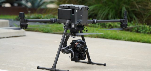
Visual Intelligence, the first unified drone sensor and software platform capable of digitizing physical infrastructure to millimeter accuracy, has announced the availability of a lightweight version of its patented MACS-3D dual-camera sensor system, designed to collect Engineering Class 3D data across all vertical infrastructure.
Developed to meet the demands of asset owners who require a precision 3D Reality Model for Engineering applications, Visual Intelligence’s new MACS-3D sensor module features a compact design that fits on various drone manufacture models, and a lightweight payload that provides increased compatibility with smaller commercial class drones – including the DJI Matrice 300 (M300). Importantly, like earlier versions, the new sensor module collects a sub-millimeter GSD to produce an emerging new category of Engineering Class drone data that is both millimeter-accurate and provides near-complete surface coverage.
“The single biggest constraint to drone data accuracy is the sensor payload, and most sensor payloads cannot deliver a class of 3D data to Engineering teams that eliminates site visits or automates structural analysis,” said Ted Miller, Founder and Chairman of Visual Intelligence. “This new lighter version of our patented sensor is key to expanding access to operators for scalable engineering-grade data collections worldwide.”
The lightweight MACS-3D sensor module includes dual 61-megapixel cameras (122 megapixels total) and a multiple axis gimbal. Unlike traditional off-the-shelf drone sensors, this sensor can achieve a GSD of up to 0.5mm at 10m+ from target, and features a high Field of View (FOV) to target ratio for greater asset coverage. The MACS-3D sensor is 50-100 times more accurate than standard off-the-shelf consumer drones and 10-20 times more accurate than mobile LiDAR sensors.
Key Features:
• New smaller payload footprint and weight.
• More point cloud detail per photo with twin 61-megapixel cameras.
• Increased pixels on target with a Field of View optimized for vertical captures.
• Simultaneous angles for increased coverage and depth.
• Safer drone flights with a farther structure standoff distance.
• Increased security with data isolation from drone manufacturer hardware.
• Customizable for various platforms and flight controllers.


