Wildlife conservation is one use for small, civil uncrewed aircraft systems (UAS) that is seldom listed among the marquee applications for the technology, such orthomosaic mapping, industrial inspection, and emergency response, to name a few, yet it has the potential to make significant contributions to environmental preservation.
That’s what I learned when June Stephens, an ornithologist submitting a paper to the national conference of the North American Ornithology Society, contacted me about using a drone to document an osprey nest. This seemed like a straight-forward mission I could knock out in less than an hour of flying, but that was before she explained that she wanted to build a 3D model of the nest and, by the way, the birds had installed radio jamming equipment around their home.

CAN YOU HEAR ME NOW?
Okay, so the birds didn’t actually rig up jammers around their nest, but they did the next best thing: they build it right on top of a cell phone tower. Prior to this assignment, I had never flown a drone near a cell tower—a deliberate choice on my part. I knew that UAS were used to conduct tower inspections, but I wasn’t aware if any special equipment or precautions were required to do it safely. Also, for years I’d heard second- and third-hand reports from other pilots of drones malfunctioning or falling out of the sky near cell towers.
That struck me as being entirely plausible. Both UAS and cellular networks rely on radio signals to function, and it makes sense that a transceiver capable of conveying hundreds or thousands of simultaneous telephone calls and wireless data connections could easily overwhelm the relatively weak control, video, and telemetry transmissions that connect a drone to its pilot.
With that in mind, I began my due diligence to determine whether or not this mission could be flown safely. I began with an Internet search, which revealed that neither cellular voice nor data connections use the same 2.4 GHz frequency as most drones, including the DJI Phantom 4 Pro+ I had selected as my primary aircraft for the mission. However, if you think I’m going to make a flight safety decision based on what Google tells me, then you haven’t been paying attention.
So, I headed out to the mission site with my UAS and a spectrum analyzer. Used by radio frequency engineers, electronics technicians and drone race organizers, a spectrum analyzer is basically a radio receiver that can pick up radio emissions across a wide range of frequencies. It won’t let you see or hear what those emissions are transmitting, but it will let you judge their relative strength and see precisely what radio bands they occupy.

To begin with, I took a reading at the base of the tower, to verify what I had read online. The signals blasting out of the cell tower were landing like artillery shells all around the drone’s operating frequencies, but without scoring a direct hit. So far, so good.
Next, I drove about half a mile away from the tower and deployed the spectrum analyzer again, which revealed the signals from the tower were much diminished. I then powered up the Phantom and its ground control station and saw a prominent spike rise in the 2.4 GHz range—grossly overmatching the signals from the tower.
Finally, I drove back to the base of the tower and put it all together: powering up the Phantom so I could see the transmissions from the cellular network and the aircraft side by side. The signals from the two sources stretched out side-by-side on the spectrum analyzer’s display, but did not directly overlap.
With growing confidence that Google had not steered me wrong, I began a series of cautious test flights, watching for any abnormalities in the aircraft’s performance, but I saw none.

A UNIQUE CASE
Persuaded that the mission could be performed safely, I followed up with ornithologist June Stephens, to find out more about her goals.
“Basically, we want to look at the materials osprey use to build their nests, as well as how they are constructed,” she said. “Also, ospreys will occasionally abandon their nests, and drones might be useful to help us figure out why.”
During our discussion, June reminded me that she was hoping to construct a 3D model of the nest using photogrammetry techniques. I’ve used Pix4D and DroneDeploy to do some basic modeling: such as stockpile estimation in a local quarry. However, I wasn’t even sure that those types of tools could be applied to something as small and detailed as a bird’s nest.

I reached out to my colleague at Embry-Riddle Aeronautical University, Dr. Joseph Cerreta, to discuss the possibility. Joe is a national expert in the field of photogrammetry and 3D modeling using UAS, so I figured he would be able to answer my questions. It turned out that not only would it be possible, but he was willing to play an active role in the process: developing a flight plan for me to capture images of the nest and processing them in Pix4D to produce the model.
“This is a unique case, because we’re trying to capture something 100 feet off the ground, but the same principles apply here as they do in other photogrammetry applications,” he said.
“We need to maintain a consistent distance between the target and the aircraft, and ensure sufficient overlap between individual images to construct the model.”
Unlike every previous photogrammetry mission I had flown, this would not merely be a matter of defining an area to be mapped, setting a ground-sample distance and letting the aircraft fly from waypoint to waypoint as I kept watch to ensure the safety of operations. Joe prepared a diagram defining a series of orbits I would need to perform around the tower using the “Point of Interest” feature in the DJI Go app.
To ensure consistent data, he suggested I employ the intervalometer built into the app, so that the camera would automatically capture an image every two seconds. While I knew this was going to be a little more challenging than a conventional waypoint-driven mission, but I still figured the aircraft would be doing most of the work.

On the day of the mission, I would discover that this was not the case. But first, we had to wait for a break in Oregon’s dreary winter weather, and it turned out that we were facing another constraint: Daddy osprey was coming home soon, and he doesn’t like drones getting up in his crib.
PLANNING AND EXECUTION
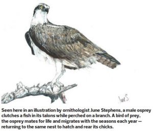
“Ospreys mate for life,” June explained. “During the winter, they migrate down to South America. The male returns in April to clean up and prepare the nest, and the female joins him a few weeks later.”
She added: “It’s important to fly this mission before the male arrives, so that we don’t scare him away, and also so that he doesn’t become aggressive toward the drone.”
Finally, the weather forecast showed a few days of overcast skies, without rain, during the upcoming week. I prefer to fly photogrammetry missions on cloudy days, so that the hard shadows created by direct sunlight don’t interfere with the assembly and rendering of the finished product.
The potential for radio frequency interference aside, this mission was uncomplicated from a planning perspective. The study site was located in Class G airspace with a ceiling at 700 feet above ground level (AGL). Since I would be flying within 400 feet of the cell tower, which itself was 100 feet tall, the regulations under 14 CFR Part 107 allowed me to fly to a maximum altitude of 500 feet AGL—although this was merely a point of trivia since Dr. Cerreta’s flight plan did not call for anything approaching that altitude.

The METAR from Aurora State Airport, the closest reporting station to our location, reported excellent visibility, no wind and an overcast cloud layer at 4,300 feet AGL. I tuned my hand-held aviation radio to Aurora’s tower frequency, to enhance my situational awareness of crewed aircraft operating in the vicinity, but there wasn’t much activity all day, and none in our immediate vicinity. The osprey was nowhere to be seen.
I took a deep breath and put my thumbs on the sticks, sending the Phantom aloft. Prior to this mission, I had scant experience with the Point of Interest capability built into DJI’s drones, so I had taken some time to practice at a park near my home. That experience made it clear to me that this flight would not be as easy as I had first imagined.
With Point of Interest enabled, the UAS did a good job of keeping the camera aimed at the target, but not a perfect job, meaning that I had to gently ride the yaw on the left stick to make sure it stayed precisely in the center of the frame. Likewise, maintaining the precise altitude that Dr. Cerreta wanted along with the distance to target required constant attention.
In short, what I had first imagined would be a tedious mission largely reliant on automation became some of the most intense and demanding flying I have ever done. It didn’t help that the operation started with a scare: Dr. Cerreta wanted the first series of images taken below the nest, looking up at it. However, the Phantom’s camera refused to tilt any higher than the horizon. After a moment of panic, I discovered that this limit was controlled within the DJI Go app, put in place to keep amateurs from photographing their own propellers, presumably.
Having flown the mission to the best of my ability, I transferred the resulting images to Dr. Cerreta, at that moment 3,000 miles away in Daytona Beach, Florida.
MAKING SENSE OF IT ALL
Processing the data would entail even more effort than capturing it had. The problem was that, in addition to the cell phone tower and the nest perched on top of it, I had also captured the surrounding neighborhood and a local high school. If the images were fed into the photogrammetry software in their entirety, it would attempt to render all of those background elements, likely obscuring the data about the nest that we had set out to model.
“It’s important for us to mask that background information out of the model,” Joe explained to me. “I’m able to do that directly in Pix4D through a process that they call ‘carving.’ Basically, I go through and highlight the background in a series of images, carving out the cell tower and the nest.”
My heart sank: I had captured more than 200 images during the mission, so it would take weeks of full-time work to excise the background from each of them. Fortunately, Pix4D is sufficiently intelligent to learn from a subset of photos which elements to discard and which to retain. Joe ended up having to hand-carve 30 of the images, a process that took about 20 hours.
“Pix4D did an excellent job of building the 3D model after I selected the background that we wanted to carve away,” he said.

As for June Stephens, she was thrilled with the finished product, which provided a unique perspective on the nest.
“At the North American Ornithology Society national conference each year, we have a track devoted to emerging technology,” she explained. “Drones have been used to study nesting behavior before, specifically in the arctic, where they were used to count tern nests.”
However, using a drone to study the structure and composition of an individual nest was breaking new ground in the field, June said.
“In this case, we learned by studying the 3D model that these ospreys prefer to use willow for their nest,” she said. “They prefer to use dead limbs which vary in size, and they also add some grasses and chickweed as padding. I was surprised to see that the nest also provided habitat for smaller birds, who built their own nests in the lower part of the structure.”
For me, this mission demonstrated that it takes a team to get results, with each person bringing their own talents and skills to bear. June had defined our goal based on her knowledge of ornithology, and even though he was on the other side of the country, Joe had effectively determined the maneuvers that would be required to accomplish it and processed the resulting data.
Even though I was the person with my thumbs on the sticks flying a difficult mission with unfamiliar technical challenges, in retrospect, I think that I got the easy part.

TEXT AND PHOTOS BY PATRICK SHERMAN


